

According to the experts at Colorado State University Tropical Weather & Climate Research Center, persistent Pacific La Niña conditions and exceptionally warm water temperatures in the Atlantic means we’re facing another season of increased hurricane probability throughout the Caribbean and eastern seaboard of the United States.
In the preceding decade, 14 storms per season on average were strong enough to be named. This year that’s projected to be 20, five of which are expected to be major, up from a decadal average of three. And the total energy rating of this season is projected to be 50 percent greater.
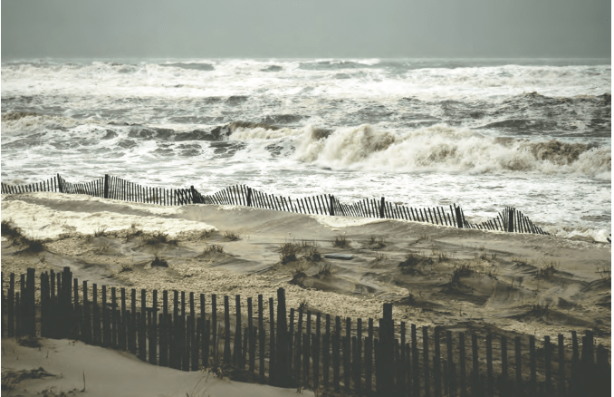
This is scary stuff. Fortunately, relatively few hurricanes make it this far north, and of those that do most are weaker by the time they get near Fire Island. But what about the ones that make it here strong enough to cause real harm, such as Superstorm Sandy?

Only months away from its decade anniversary, Sandy was labeled a “superstorm” because although it was extremely large, by the time it reached us it no longer fit the technical definition of a hurricane. Yet it did a stunning amount of damage region wide. By examining the conditions that created Sandy we can learn a lot to help us understand future storms.
Trust the experts and follow the advice of local authorities if they suggest evacuation. But if you want to make your own assessment, there are five important things to consider.
The strength of the storm: The greater the intensity the greater the potential for harm. But as we saw with Sandy, the factors below can also play a large role.
The diameter of the storm: Most hurricanes are between 200 and 300 miles wide. But if they combine with other storms as they move up the coast toward us, they can grow considerably larger. For example, Sandy was almost 1,100 miles wide.
The path of the storm: Winds and storm surge are strongest in the northeastern quadrant of a hurricane, so if the storm makes landfall a bit to our south, we’ll get hit harder than if it makes landfall north of us. This is exaggerated by the New York-New Jersey coastline, which forms an “L” shape that concentrates the surge. High tides make it even worse, as does the position of the moon. Basically, the storm’s counter-clockwise rotation causes the northeastern quadrant to blow water onto the beach, whereas the northwestern quadrant blows it away from the beach. If it’s predicted to make landfall directly on Fire Is- land or within 100 miles to the south, then even a low-grade storm can be very dangerous.
The speed of the storm: Slow moving storms (less than 15 miles per hour) linger long enough to drop much more rain and build up a major storm surge.
Regional weather conditions: A smaller storm merged with Sandy, increasing its potency. Then a cold front to the west increased the temperature gradient of the storm, driving even more rain and wind, further increasing the surge. Watch out especially for blocking high-pressure region over New England that can steer a storm directly into us, as happened with Sandy or Irene in 2011.
Despite the obvious dangers, if you decide to stay on the island – or if you’re caught unawares – at least be prepared. Make sure you always have flashlights with spare batteries, a reasonable reserve of food and bottled water, and at least a week’s worth of any regular medications. And don’t rely exclusively on your smart phone to provide information, it’ll be useless if a major storm disables the cellular base stations within range. Make sure you have a small battery-operated radio to receive news and emergency broadcasts. It takes just an hour or two to make these preparations, but it can save you lots of grief.
Lastly, take the warnings and recommendations of local authorities seriously. Sure, maybe you can dodge falling trees and flying deck furniture, or jump over downed power lines. But you’re not going to escape a storm surge, the ocean itself rises up and the water flows everywhere with enough force to wipe out buildings. What chance do you stand against that?