
NPS/Fire ISland National Seashore
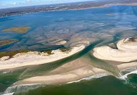
New Inlet has regained its status as Old Inlet, running dry nearly a decade to the day after Superstorm Sandy breached the former colonial-era waterway that had been sealed up centuries ago.
After the inlet turned to sand around the 2012 storm’s Oct. 28 anniversary, the thinnest part of the island then swung open again like a pair of old saloon doors following a relatively minor winter storm, then dried up again. The development raises questions about everything from water quality in Bellport Bay to the renewed ability to drive off the island eastbound through Smith Point County Park, but many of those answers are up in the air.
“From a scientific perspective, it’s an inlet and there may still be some flow depending upon the day of the week,” Brendan Newell, the new Chief of Resource Management at Fire Island National Seashore (FINS), told the News. “Technically, it’s not closed … As far as the evolution of the area, it’s going to open and close as it does naturally with forces like big storms.”
The inlet was one of two that Sandy caused on Fire Island. The other, at Smith Point County Park on the easternmost portion of the barrier beach, was filled in by the U.S. Army Corps of Engineers shortly after the storm, same as a third breach at Cupsogue County Park in Westhampton just across the Moriches Inlet from Smith Point.
The process that played out over the past decade offered some insights for FINS. That’s because the breach at the area known as Old Inlet occurred within the boundaries of the Otis Pike High Dune Wilderness Area, an eight-mile stretch of pristine, undeveloped beach – the only federal wilderness in New York State and the smallest in the National Park System. Its status meant FINS was bound by federal law to let nature take its course, as opposed to the western, residential portions on Fire Island, where Army Corps contractors dredged sand from offshore and pumped it onto the beach to build up berms and manmade dunes. Local elected officials had urged FINS to close the inlet after the storm, fearing it would cause flooding on the South Shore of Long Island.
“It’s been a very educational opportunity to understand how the sediment dynamics of Fire Island would play out naturally in the absence of development,” Newell said. “In this case, we’ve seen a lot of response from local wildlife, there’s been a lot of birds using the area, it’s been exciting to watch new dunes develop and this area will continue to evolve and eventually may breach again or there may be a breach in a different area.”
Besides wildlife, New Inlet also proved beneficial to marshland.
“We’re learning about the value of sediment being transferred from the oceanside to the bayside in a way that is typically interrupted when humans intervene by building up dunes and building houses in between,” he added. “It’s a very interesting place when you can compare it to just a few miles away down the beach on Fire Island, where there is development. [At New Inlet] we’re actually seeing new salt marshes develop in bay areas in contrast to the rest of the bay areas, which are generally eroding and submerging because there’s no fresh sediment to supply it.”
Bolstered marshland is in addition to the widely reported environmental benefit of flushing fresh saltwater into the back bay, where excess nitrogen pollution has caused brown tides that have historically hampered the marine ecosystem.
“Obviously allowing the flushing through the inlet contributes to changes in water quality,” Newell said.
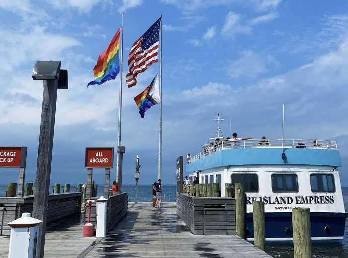
Allowing the inlet to naturally dry up also offered the first chance in a decade for off-road vehicles to drive on and off the seashore through Smith Point. Since the breach, everyone in the easternmost communities such as Davis Park and Fire Island Pines has had to drive off through Robert Moses State Park to the west.
“We were allowing emergency vehicles to go through that area,” Fire Island National Seashore Superintendent Alex Romero said, noting that FINS is monitoring the area.
Non-emergency vehicles are less of an issue, as most permits for residents to drive on the beach are concentrated on the west end and there are few year-round residents in the eastern communities. But even for emergency vehicles, there is piping plover nesting season to beware of across the full length of the island through much of summer.
When exactly might Old Inlet ebb and flow with the tide anew? Experts can’t say for sure.
“It’s like crystal balling,” said Romero. “Could it be a little river during high tides and storms? It’s so hard to predict. The whole island is vulnerable.”