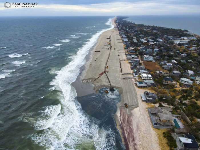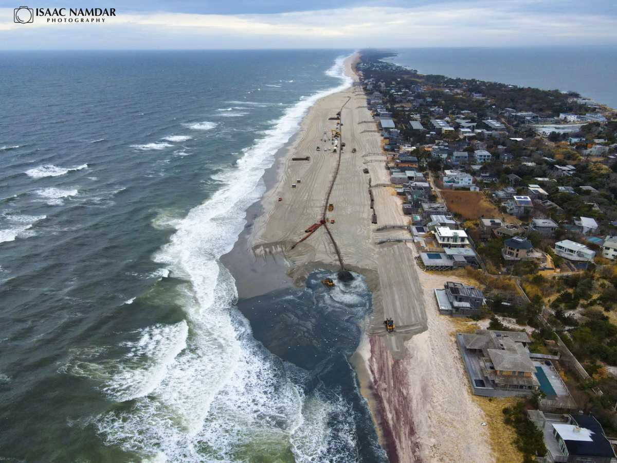
The Fire Island beaches look as beautiful as postcards with plentiful dunes and wide expanses, in part due to massive amounts of sand used to replenish them. And summer winds have been shifting sand back to the beach ever since Super Storm Sandy and other storms took big bites out of the shore.
The big winds of change lately, however, have come from Albany as New York State authorized spending up to $1.7 billion on Long Island’s South Shore from Fire Island to Montauk against storms and erosion.
As part of the project, New York State Gov. Kathy Hochul and the state legislature authorized, but did not appropriate, money over 50 years, to be supplemented by federal and local funds to fortify storm-prone shores from Fire Island to Montauk.
That includes about $1.3 billion and $430 million in two separate items in the New York State budget, for services and expenses related to the “non-federal share” of the Army Corps of Engineers Fire Island to Montauk Point project.
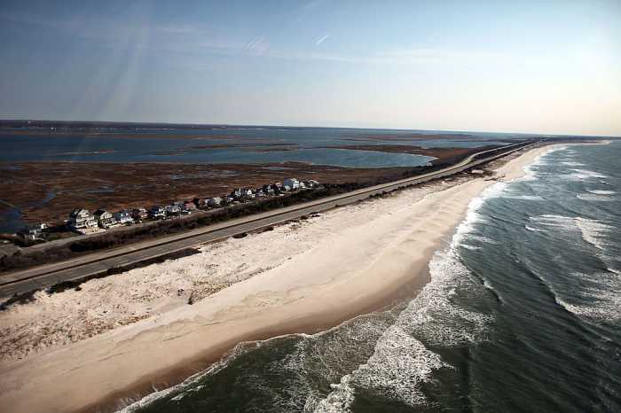
Barrier islands, such as Fire Island, are not only home to thriving communities, but protect Long Island’s South Shore.
New York State Department of Environmental Conservation spokeswoman Cecilia Walsh said Gov. Kathy Hochul made a push to protect barrier islands and the South Shore rather than reacting to emergencies.
“New York has prioritized resiliency work as severe weather and once-in-a-hundred-year storms have become the norm,” Walsh said. “The language included in this year’s enacted budget ensures that the state is able to work to protect Fire Island and the South Shore of Long Island and to undertake vital coastline resiliency work over the next five decades.”
Henry Robin, president of Fire Island Pines Property Owners’ Association and a staunch advocate for the region, said Fire Island has been winning big battles and getting support.
He pointed to a $52 million emergency beach project the feds paid for that rebuilt the east Fire Island beaches this year as well as the latest developments. He worked closely with Seaview Association President Tom Ruskin in fighting for the project.
“The last two years have been challenging and ultimately exhilarating. Many of Fire Island’s communities faced an existential threat after the storms of 2022 and 2023, and tremendously long odds of getting the government to come to our aid,” Robin said. “The battle for the government to step in ended in a victory that saved many of the island’s east end beaches. We showed what communities can do when they fight for themselves.”

Decades and dollars
The $1.7 billion funding related to Fire Island and the South Shore, hardly a lump sum, would be dispersed over 50 years, but only 30 for Fire Island. But money hasn’t yet been appropriated or matched as it must be.
“They’re not raising the money now through state bonds or taxation. They put a line in the budget, saying this money is authorized to be spent over the next 50 years, if there is a need and if a project is agreed upon,” said Suzy Goldhirsch, president of the Fire Island Association.
She said the $1.7 billion for The Fire Island to Montauk Point Coastal Storm Risk Management Project (FIMP) is “an estimate of the highest possible cost it could be. In other words, based on the estimated cost if every project in FIMP was renourished every four years, which is not going to happen.”
“The number is huge, but it won’t be that costly,” Goldhirsch said. “The east and west ends of Fire Island were just renourished, a year and a half ago, with a different Army Corps pot of money the federal government often provides for emergencies.”
Partners in protection
State money also needs to be supplemented by federal and local funds. “It’s a three-way partnership,” Goldhirsch said. “And it will fund projects in the future for all of the South Shore of Long Island, not just Fire Island.”
Federal money would have to be authorized by Congress in the Army Corps budget every two years to fund the 50/50 split between federal and non-federal funds. The non-federal share is then divided, 70% funded by the state and 30% paid for by the local sponsors.
All five FIMP towns are the local sponsors — Babylon, Islip, Brookhaven, East Hampton, and Southampton. They must sign project participation agreements, or PPAs. Suffolk County is also a local sponsor for their beaches.
Battle of the beaches
If FIMP gives hope, as money flows to implement it, that plan follows years of dealing with expensive emergencies. After Sandy and other storms hit, the federal government, including the Army Corps of Engineers, agreed to 100% fund a project to rebuild all of Fire Island from Kismet to Davis Park, which was finished in 2019.
When subsequent storms struck the eastern half of Fire Island from Seaview to Davis Park, including the Pines, the federal government determined that the storms did not meet the thresholds to trigger emergency assistance.
“That began an epic campaign for Eastern Fire Island,” said Andrew Kirtzman, on the board for the Fire Island Pines Property Owners’ Association. “That was basically a campaign to save Eastern Fire Island.”
Gov. Hochul helped allocate $3 million for a temporary fix, including placing trap or sandbags in front of houses. The Army Corps approved a $52 million emergency project to rebuild the beaches on Eastern Fire Island, covering the Pines, Davis Park, Ocean Bay Park, Point of Woods, and Seaview.
And the government began to implement FIMP, under which every four years the Army Corps of Engineers is required to look at the beaches and replenish. Emergency beach projects are massive and expensive, but FIMP guarantees periodic renourishments rather than simply reacting to emergencies.
The facts about FIMP
The Fire Island to Montauk Point Coastal Storm Risk Management Project, which the $1.7 billion would help fund, is designed to protect Fire Island and Long Island’s South Shore from hurricanes and beach erosion along 83 miles of shoreline between Fire Island Inlet and Montauk Point.
This State funding, through the Department of Environmental Conservation, according to the budget, includes material to support shorelines, beach berms, dunes “at appropriate intervals,” periodic “renourishment” of these materials, and elevation of structures on floodplains.
“Generally speaking, capital projects are spread out across multiple years,” said Ken Lovett, a spokesman for the Governor’s office. “And depending on the size and scope of a project, it can bleed into decades.”
Goldhirsch agreed that Army Corps projects like this typically span decades. “That’s the life of big Army Corps projects like this,” she said. “It’s a big project. It’s usually a 50-year deal.”
While these funds would span decades, Lovett said, even future funding through the budget is set in place. “Enacted budgets are state law, so unless a new administration wants to change the law in the future, that’s how capital projects are traditionally funded,” Lovett said.
“The National Park Service doesn’t allow restoration of its federal lands. They believe in letting nature take its course,” Goldhirsch said. “They also would only agree to renourishment on Fire Island for 30 years, not 50 years. We’re now three years into that timeframe, so it’s 27 years to go.”
Farewell to FEMA
Projects have historically been undertaken after emergencies, ranging from Gilgo Beach to the East End and Fire Island, making the foresight in planning a $1.7 billion historic achievement.
“We have renourished our beaches for years now, since the 1990s. The first projects were FEMA based. After Sandy, FIMP was authorized,” Goldhirsch said. “Going forward, any Amy Corps repair or renourishment of Fire Island beaches will be based on when it’s needed and when funds are available.”
She said routine renourishment is estimated every four or five years based on a template for the height of the dune and the width of the beach.
The Army Corps uses devices with lasers that measure the beaches for the 17 Fire Island communities. The template for dunes on Fire Island, Goldhirsch said, is 15 feet above sea level, and the beach or berm template is 90 feet wide.
FEMA, she said, would no longer be involved in this regular replenishment designed to avert or help protect against emergencies.
“Once a project becomes an Army Corps of Engineers project, FEMA no longer gets involved,” Goldhirsch said. “After Sandy, the governors of New York, New Jersey, and Connecticut went to Washington. They got appropriations for Sandy repair and recovery, and that’s how FIMP was finally authorized, after 60 years of planning.”
The Army Corps will monitor the beaches, seeing whether they need repair, so they can plan ahead rather than simply reacting to emergencies.
“Maintaining the integrity of the barrier islands along the South Shore of Long Island is important for the safety of the South Shore of Long Island, which is at zero feet above sea level,” Goldhirsch said.
Funding for the Water Resources Development Act, including these projects, comes up every two years, as the Army Corps puts in its national budget. “It’s Congress’ decision,” Goldhirsch said. “They vote on the Corps appropriations.”
Structure
While Fire Island is likely the most famous barrier island in the region, a string of barrier islands speckles the region from Jamaica Bay to the Hamptons. Those include Jones Beach, Coney Island, Long Beach, the Rockaways, Westhampton Beach, as well as the beaches east of the Shinnecock Canal.
“There’s a long line of barrier islands that protect Long Island and New York City from the ocean,” Goldhirsch said. “These barrier islands protect so much critical infrastructure.”
Fire Island has relied primarily, if not entirely, on replenishing sand to strengthen against storms, although that’s not the case everywhere.
Goldhirsch said Fire Island isn’t allowed to have other kinds of structures, and that the National Park Service wouldn’t permit it. On the East End in the Hamptons, on the other hand, they use rock structures.
Groins or jetties are used in some areas, such as the Rockaways, although two groins were built near Fire Island in the 1960s.
Groins or jetties were constructed at Georgica Pond in 1965 in the Hamptons, followed by 11 in Westhampton Beach and four more that followed. These can actually do damage, leading to water scooping sand near them.
“If you build them, you have to build them the length of the island,” Goldhirsch said. “Where you stop building them, the ocean scoops out the sand on the other side.”
Natural defenses
Fire Island, in particular its western section, has been stable for 1,400 years with sand that comes and goes, Goldhirsch said. Over the last 20 or 30 years, there has been more climate change, sea level rise, and storms that pull out sand, requiring renourishing the beaches.
The ocean doesn’t just steal sand, but replenishes also, depending on the tides and wind that can break down or build a beach.
During the summer, sand gets pushed back to beaches by the southwest winds that actually build up the beaches to make them very wide. “They’re wide now,” Goldhirsch said.
Storms, on the other hand, can take sand and move it out to the sand bars. And in the winter, north and northeast winds can narrow the beaches, which then build up again in the summer.
“That’s the natural sand transport system of our barrier island,” Goldhirsch said. “What the Army Corps plans to do is add more sand into that system.”
She said the Army Corps uses sand dredged from borrow areas way offshore in the ocean that are explored, mapped, sampled, and tested to make sure it is consistent with the required grain size.
The plan
The Fire Island Stabilization Project, which preceded FIMP, consisted of a one-time sand placement along Fire Island, from Robert Moses State Park to Smith Point County Park. Work was completed in Smith Point County Park in 2016, followed by work at Robert Moses State Park through Saltaire later that year.
Work at Fair Harbor through Seaview was completed in November 2017, with contracts focusing on Fire Island communities from Ocean Bay Park through Davis Park. A beach fill contract from Ocean Bay Park through Davis Park was substantially complete in June 2020, according to the Corps.
The Project’s final contract for relocation of the Ocean Beach water utility was awarded in August 2020, with a new round of projects in the works.
“Beach reaches will be surveyed annually to determine priority for placement contracts,” according to the Army Corps of Engineers.
The goal, the Corps said of this new preventive rather than reactive approach, “is to reduce risks associated with coastal storms within the study area, as well as to reestablish and enhance the natural coastal processes that replenish beaches and enhance ecological resilience.”
The project was initially entirely federally funded to the tune of $1.9 billion, with future work to be shared with the state and partners. Work for West Hampton is scheduled to be awarded in the summer of 2026 to complete the initial construction work.
Various contracts have been awarded with work already done, such as the dredging of Fire Island, Shinnecock, and Moriches inlets and shoals, and placement on Gilgo Beach, Robert Moses State Park, and Downtown Montauk.
Work that has been done, at least so far, has left Fire Island beaches in good condition now, even as winds whip around the island. So, while the $1.7 billion is good news, the state of the sand itself is equally uplifting.
“The beaches look OK. Our beaches are in good shape. We’re coming to the end of summer. A lot of sand has been coming in with the southwest wind,” Goldhirsch said. “But the beach can get narrower during the winter, because prevailing winds are north and northeast, which pulls sand out to sea.”